|
LandDesign is a map editor, with many more
features than only drawing terrain and elevations. It is the first map editor
that works under Windows 95/98/ME/NT/2000/XP
and can use mouse. It can handle objects,
like complexes, mines, bases etc. MUX maps
can be imported and exported. Also, as far as I know, it is the first map editor
ever that can handle map sizes of up to 1500x1500.
Support for printing maps is included too.
 |
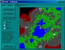
This is how LandDesign looks in general. |
 |
A few of the file functions LandDesign has.
They include importing and exporting MUX map files, in the format the BattleTech
MUX sites will read. |
 |
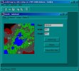
On main display, you can change size of existing
maps, import log sessions etc. It also shows an overview. |
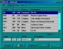 |
Object definitions. These objects are optionally
displayed on exported image file, and also used by HUD. These can also be
used as Jump-Points in the editor. |
 |
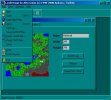
This is where the image that is to be exported
is prepared. You choose what to see on the image, and then simply save it. |
 |
The mighty editor. Mouse usage is possible.
Also brush sizes, move factors etc. With recent editions (fill, line, mouse)
it has become really easy to use. |
|